The Sib and Lulu VMS showings lie on the west limb of the Eskay anticline, with Sib located ~4 km southwest of the world-class Eskay Creek mine. VMS mineralization occurs at several stratigraphic positions within the Hazelton Group (Figure 1), with mineralization at Sib primarily hosted by peperitic rhyolite within the upper part of the Spatsizi Formation (Figures 1 and 2), and the highest grades at Lulu hosted within peperitic Eskay rhyolite (Figures 3-5).
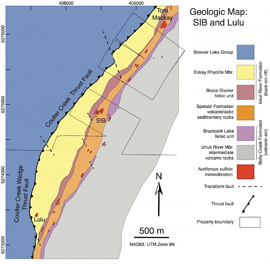
Figure 1: Simplified geologic map of the Sib and Lulu zones (modified from Lewis, 2013). VMS mineralization occurs at several stratigraphic levels within the Betty Creek and Iskut River Formations.
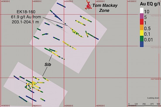
Figure 2: Map view of the Sib zone showing drill hole assay results in Au equivalent (Au+Ag/78). Precious metal mineralization is predominately hosted by peperitic rhyolite in the upper part of the Spatsizi Formation, and extends to the Tom Mackay zone on Skeena Resources ground. The pink boxes show the boundaries of the Consolidated Eskay Property in this area. Drill hole EK18-160 intercepted 61.9 g/t Au over the interval 203.1-204.1 m.
The Lulu Zone is characterized by semi-massive to massive Ag sulfosalt mineralization hosted by intensely altered mudstone associated with peperitic Eskay rhyolite (Figures 3-6). Based on the stratigraphic position of high-grade mineralization at Lulu, it is likely this zone is at a time-equivalent horizon to the Lower Mudstone at Eskay Creek. Electrum is the primary host mineral for Au at Lulu, and across the property (Figure 6).
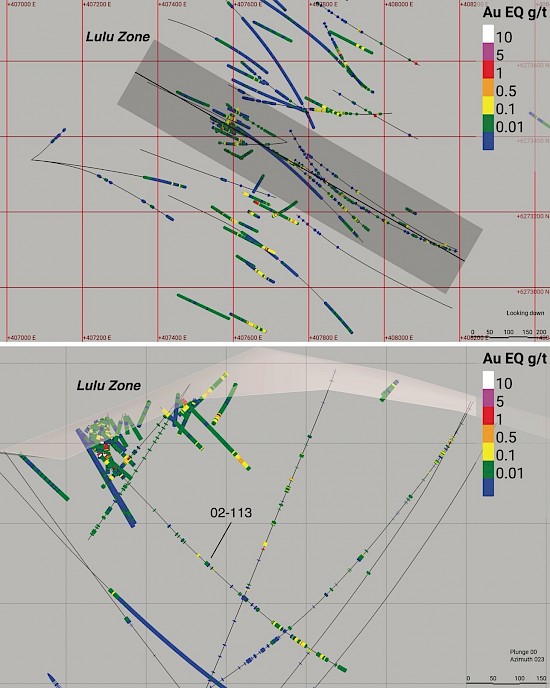
Figure 3: Map and cross-section views of the Lulu zone showing assay results in Au equivalent (Au+Ag/78).
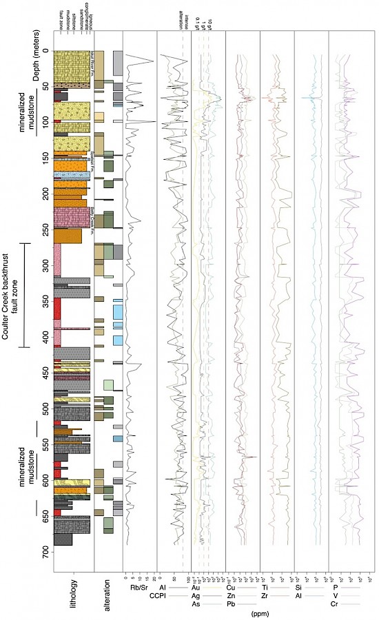
Figure 4: Core log with assays and select lithogeochemical data for drill hole 02-113 from the Lulu Zone. Gold and silver mineralization occurs at several stratigraphic levels, with the highest grades reported from mudstones within the Eskay rhyolite. Based on the stratigraphic position of this high-grade mineralization, it is likely the time equivalent horizon to the Lower Mudstone at the Eskay Creek deposit ~4 km to the northeast. Mineralization is closely associated with intense hydrothermal alteration as indicated by the high Ishikawa alteration index values (AI) occurring with high Au and Ag values.
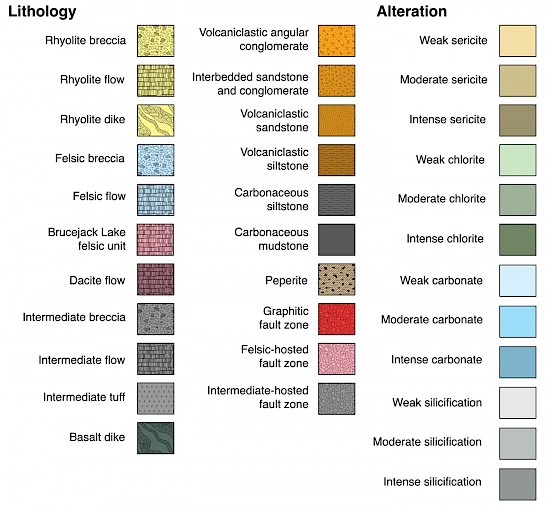
Figure 4 continued: The legend for 02-113 core log.
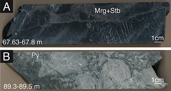
Figure 5: Samples from 02-113. A: Mineralized mudstone breccia with stibnite (Stb) and miargyrite (Mrg) filling space between mudstone fragments. B: Representative sample of peperitic rhyolite at lower contact with the overlying mineralized mudstone.
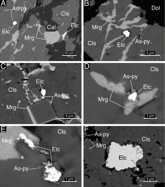
Figure 6: Back-scattered electron microscope images illustrating electrum replacement of the silver sulfosalt mineral miargyrite in sample 02-113 67.2 m. Electrum is the primary host mineral for Au in the Lulu Zone and at other VMS showings property-wide.
The Hexagon-Mercury Zone lies ~750 m to the southeast of the Lulu Zone, and extends towards Jeff North ~3 km southeast of the Lulu Zone (Figures 7 and 8). This zone is defined by an Eskay Creek-like magnetic anomaly (Figure 7), as well as a trend of stratiform conductors extending from Jeff North towards Hexagon-Mercury (Figure 8). Results from soil sampling in 2021 and 2022 show Ag, Zn, and Hg anomalies extending northwards along the east limb of the Eskay anticline (Figure 9). Legacy rock chip sample assays indicate the presence of Au along the trend of magnetic and conductive anomalies (Figures 7 and 8). Historic drilling at Hexagon-Mercury intercepted Betty Creek Formation-hosted sulfide mineralization with grades up to 8.08 g/t Au over 2 m in drill hole 03-127, as well as Hg values up to 100 ppm. Preparations were made in 2022 to access this rugged area for exploration during 2023.
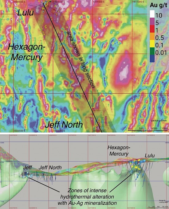
Figure 7: A 2 km thick vertical slice looking west at the Jeff North-Hexagon-Mercury target. The center line of the slice is oriented along an azimuth of 340 degrees, oblique to the UTM grid and rotated 20 degrees from the viewing plane. The light green volume shows the 0.001 SI magnetic susceptibility 3D model. Zones of intense hydrothermal alteration (an Ishikawa alteration index greater than 80) are modeled as light blue volumes. The area between Jeff North and Hexagon-Mercury hosts prospective magnetic anomalies that lie on trend with Au and Ag mineralization located by drilling and rock chip sampling.
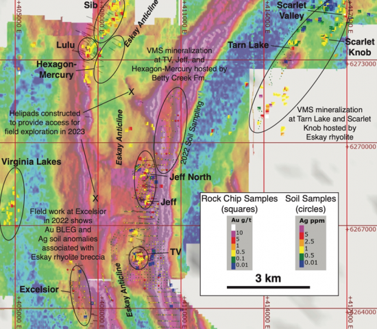
Figure 8: SkyTEM conductivity map of the central and southern Eskay anticline showing legacy rock chip Au concentrations (squares), and 2021-2022 soil sample Ag concentrations (circles). These data in combination with drilling along the TV-Jeff and the Eskay Creek-Sib-Hexagon-Mercury trends suggest that VMS systems occur within the Lower Hazelton Group along the length of the Eskay anticline. Soil sampling and prospecting at Excelsior in 2021-2022 show that Ag anomalism in soils and a Au BLEG anomaly is associated with Eskay rhyolite, suggesting VMS mineralization within the Upper Hazelton Group also extends well south of the Eskay Creek mine.
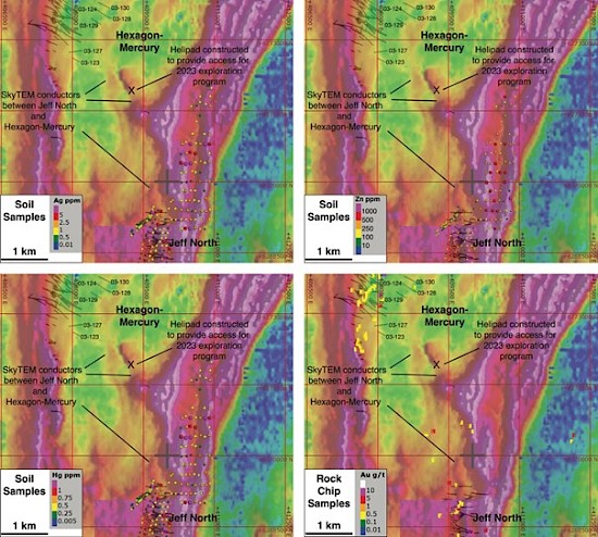
Figure 9: SkyTEM conductivity maps focusing on the underexplored area between Jeff North and Hexagon-Mercury. Results from soil sampling in 2021 and 2022 show Ag, Zn, and Hg anomalies extending northwards along the east limb of the Eskay anticline. SkyTEM data shows stratiform conductors extending from Jeff North towards Hexagon-Mercury. Historic rock chip samples indicate the presence of Au along these conductors. Historic drill holes at Hexagon-Mercury are noted, and intercepted Au and Ag mineralization, as well as Hg values up to 100 ppm.
