The North Mitchell and Ted Morris showings lie along a larger northeast-southwest trend of Cu-Au porphyry deposits that includes KSM, Iron Cap, and Treaty Creek (Figure 1) that comprise a total indicated Au resource of over 100 million ounces, and a Cu resource of over 20 billion pounds. Prospecting and BLEG surveys of North Mitchell, Big Red, and Ted Morris shows high Au and Cu concentrations associated with the chalcopyrite, bornite, and chalcocite. BLEG anomalies between Ted Morris and Kerr suggest that this area has widespread potential for Cu-Au porphyry deposits.
Big Red and Ted Morris
The Big Red and Ted Morris showings are located approximately 1.2 km southeast of Vermillion. Numerous Au-bearing rock chip samples have been collected over this large area (Figure 1), with the most intense mineralization associated with extensive gossanous outcrops of lower Hazelton Group rocks (Figure 2). Rock chip and soil sampling conducted during 2016 in this area indicates the presence of an extensive zone of copper enrichment that is also associated with Au enrichment in the northwestern part of the showing (Figures 3 and 4). Copper mineralization is vein-hosted, and characterized by chalcopyrite, chalcocite, and bornite. This mineralogy is consistent with Cu-Au porphyry-type mineralization, and may represent a southwestern extension of the Treaty Creek-KSM trend of porphyry deposits. Host rocks at the nearby Vermillion and Red Lightning showings are lower Hazelton Group andesite and associated sedimentary rocks, and of the proper age to host porphyry mineralization.
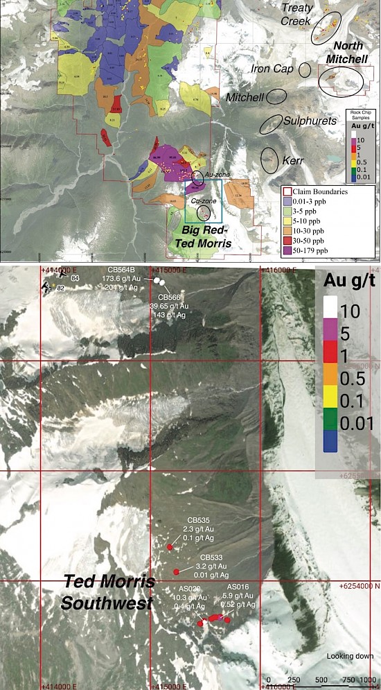
Figure 1: Map (top) showing the trend of porphyry deposits extending from Treaty Creek (Tudor Gold), to North Mitchell (Eskay) KSM-Iron Cap (Seabridge Gold), and the Big Red-Ted Morris target (Eskay). Strong BLEG results between Kerr and Big Red-Ted Morris suggest Au mineralization extends between these two areas. The blue rectangle defines the area covered by the map of the Big Red-Ted Morris area (bottom).
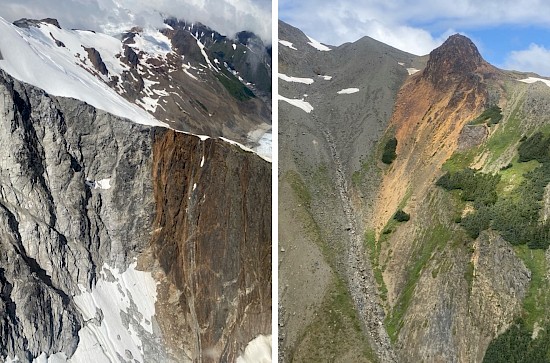
Figure 2: Photographs of gossans at the Big Red-Ted Morris target. Gossans are strongest in area with high densities of quartz+sulfide veins.
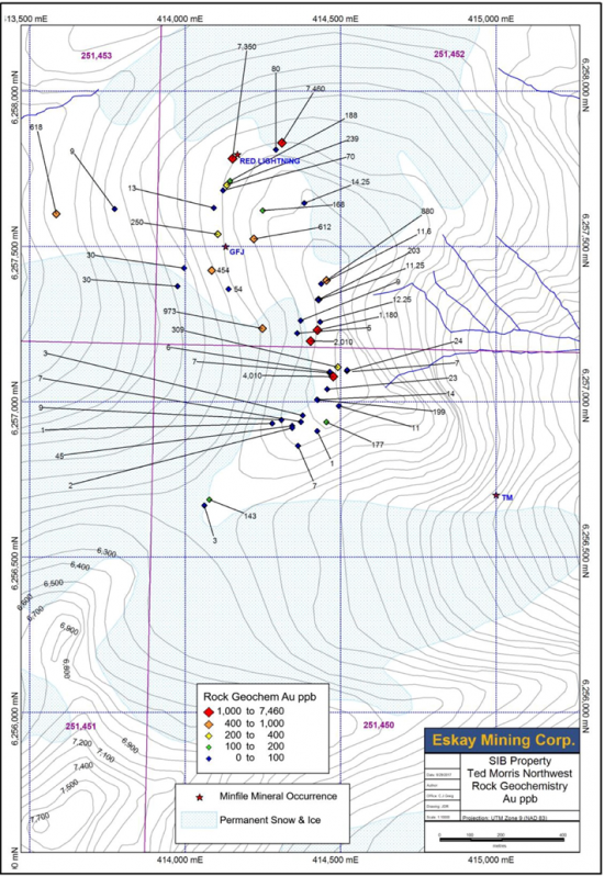
Figure 3: Results of Au assays for rock chip samples from the 2016 prospecting program in the northwestern portion of the Big Red-Ted Morris area (1,000 ppb=1 gram per metric ton).
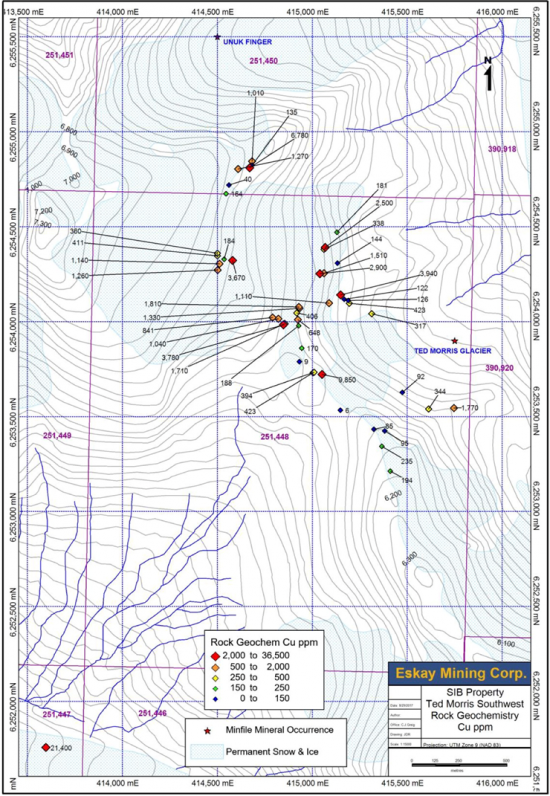
Figure 4: Results of Cu assays for rock chip samples from the 2016 prospecting program in the southwestern portion of the Big Red-Ted Morris area (1,000 ppm=0.1%).
North Mitchell
The North Mitchell claims cover 14.5 square kilometers adjacent to the KSM Cu-Au-Ag-Mo deposits and the Valley of the Kings gold deposit (Brucejack), and is 19 km southeast of the Eskay Creek precious metals-rich VMS deposit. Much of North Mitchell is steep and glaciated however there is considerable exposure north of Mitchell Glacier (Figure 5) where prospecting and BLEG sampling have been conducted. The southwestern part of North Mitchell hosts lower Hazelton Group andesites and associated sedimentary rocks (Figure 6), the same host rocks as the precious metal-endowed Valley of the Kings, Iron Cap, Mitchell, and Treaty Creek deposits. BLEG sampling shows a strong 27.64 ppb Au anomaly, from the single drainage that was able to be sampled in this rugged area. Prospecting of this area conducted in 2016 identified strongly anomalous Au, Ag, Cu, and Mo concentrations (Figures 7-10) associated with veins of quartz, chalcopyrite, and bornite. This mineralogy is consistent with porphyry-style mineralization.
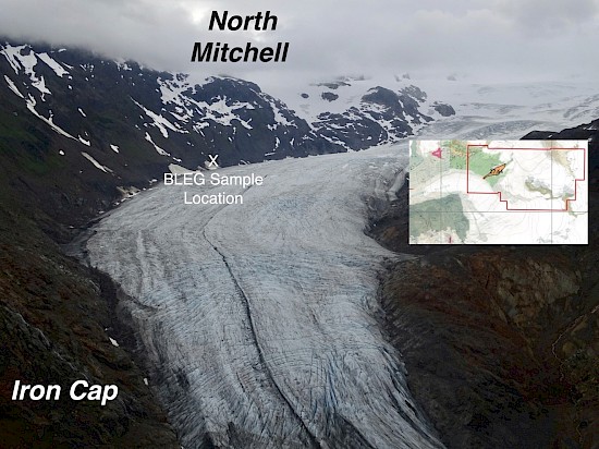
Figure 5: Photograph looking east of North Mitchell (background), with a portion of the Iron Cap gossans visible (foreground). The inset map shows the drainage catchment (orange polygon) associated with the strong (27.64 ppb Au) BLEG anomaly at North Mitchell, with the sample location marked by the X in the photograph. The lithological units shown in the inset map are from Lewis (2013).
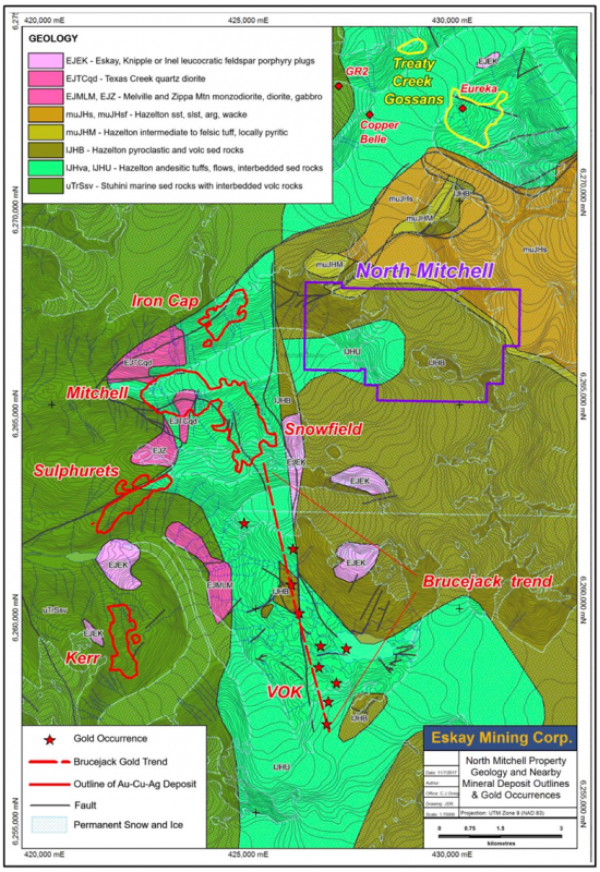
Figure 6: Porphyry-type Au-Ag-Cu deposits located near the North Mitchell property.
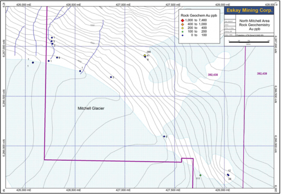
Figure 7: Results of Au assays for rock chip samples from the 2016 prospecting program in the southwestern portion of the North Mitchell claims.
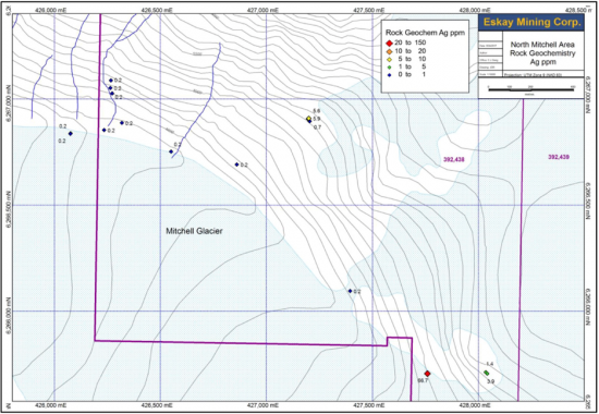
Figure 8: Results of Ag assays for rock chip samples from the 2016 prospecting program in the southwestern portion of the North Mitchell claims.
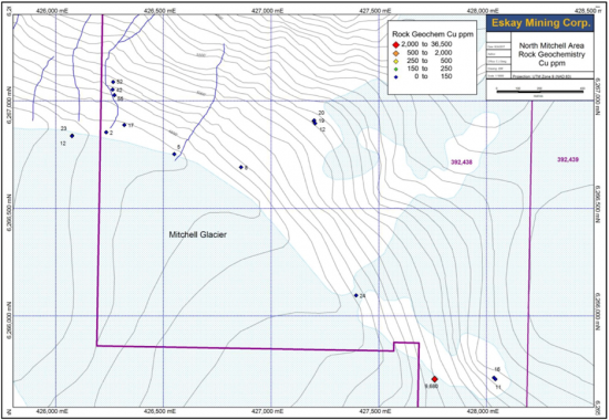
Figure 9: Results of Cu assays for rock chip samples from the 2016 prospecting program in the southwestern portion of the North Mitchell claims (1,000 ppm=0.1%).
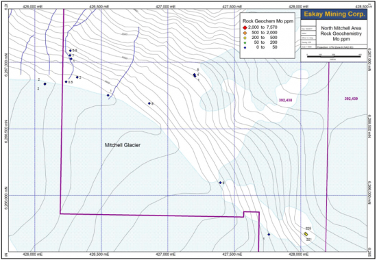
Figure 10: Results of Mo assays for rock chip samples from the 2016 prospecting program in the southwestern portion of the North Mitchell claims.
